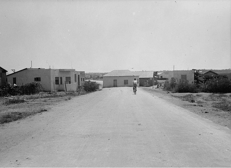
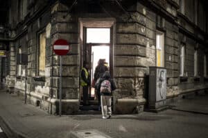
“Jewish house blocking asphalt highway between Yehudieh and Tel-Aviv” (ca. 1934–1939) | Matson (G. Eric and Edith) Photograph Collection, Library of Congress
I spent the summer of 2025 in Bayt Lahm (Bethlehem), conducting archival research in the Jacir family’s historic dar, a beautiful two-story home built in the nineteenth century from Jerusalem stone. Taking a break one afternoon, I watched a short film, Mehdi Amel:The Colonial Mode of Production (2024), by the artist Mary Jirmanus Saba, a compilation work based on the writings of the Lebanese Marxist philosopher. A clip in Saba’s film caught my attention. In it, an occupant of a refugee camp in Gaza stated,“We do not approve of an operation for widening roads because it is not a question of widening roads, it’s a question of evacuation.”
I asked a friend, Tamara Maatouk, an expert on Arab cinema, where this cut came from. She told me it was from Mustafa Abu Ali’s Scenes From the Occupation in Gaza (1973),a documentary which focused, in particular, on Gazans living in camps in the 1970s (the children who featured in Ali’s work would be in their fifties, sixties, and seventies today—if they have survived the hard intervening decades and the last two years of the intensified genocide).
In Bayt Lahm, stepping out of the house for fresh air—a cigarette—I gazed upon the apartheid wall that severs the West Bank from 1948 Palestine (Historic Palestine). The wall was built in 2002 on top of the Jerusalem-Hebron Road, dividing and rendering defunct an old and well-traveled route, historically used by travelers from all across Palestine, as well as Egypt and Lebanon.
That summer, I was collating information on migrant laborers during the Mandate period (1922–48) for my thesis project. In tandem with the work I was doing in Bayt Lahm, I began trawling through the Eric G. Matson photograph collection (online), which spans the late Ottoman and Mandate period (1850–1948). It contains pictures taken from all over Palestine that were sold through the American Colony in al-Quds (Jerusalem). Thinking about the divided Jerusalem-Hebron Road just outside my door and the fact that many migrant laborers worked in paving and construction for the British during the period, I inputted the term “road” (and then its synonyms) into the search function. While the results returned no sign of laborers, I came across something uncanny.
At first, the photograph seemed congruous. A man is cycling on a road towards a house, perhaps after a day of work. However, upon closer inspection, I noticed something. The home is not to the side of the road, nor at the end of it—like a cul-de-sac—as one would expect. Instead, it is on top of it. The road protrudes out from behind the house. The mortar home cuts the asphalt path in two—just like the apartheid wall meters away from where I sat.
What was the house doing on top of the road? To answer this, I first needed to contextualize the photograph.
The Library of Congress—where the Matson collection is housed—dates the photograph between 1934 and 1939. This period was colored by heightened tensions and, at points, all out revolutionary violence, particularly during the Great Revolt (1936–39), or al-Thawra al-Kubra—a three-year Palestinian and Arab uprising against British rule and Zionist colonization. While there were factors specific to the immediate period that led to intercommunal tensions and the Revolt, pressure had been mounting for some time between Zionist settlers, British colonial rule, and the local Palestinian and Arab population.
In May of 1921, the year before the Mandate started in earnest, riots broke out in Yafa (Jaffa). Originally emerging between Jewish communities, the disturbances developed into internecine violence. Later, in August 1929, following agitation by Zionist groups led by Betar (Brit Yosef Trumpeldor Youth Movement) at the al-Buraq wall of the Haram al-Sharifin al-Quds, violent demonstrations unfolded between Jewish settlers and Palestinians. In the early 1930s, following increased Jewish migration—both of people and capital—the cost of living rocketed, as did the commodification of land. The many Palestinian peasants and workers alienated from their livelihoods would go on to participate in the general strike from April to October 1936, which historians generally treat as the first stage of the Revolt.
Through the Revolt, British colonial bureaucrats stepped up their efforts to pacify Palestine. Between 1936 and 1939, they built 840 kilometers of streets and paths—one third of all road infrastructure constructed during the 25 year-long Mandate—enabling their soldiers and police to move swiftly around the country, and confront the revolution head-on.
Between 1937 and 1939 the country experienced new levels of instability. Palestinian thuwwar (revolutionaries) assassinated Lewis Andrews, Acting District Commissioner of Galilee, a known Zionist sympathizer, who a Hagannah member later noted, “wanted … to organize a Jewish defense organization quite openly.” The thuwwar also established a wide network of informants and spies, and instituted courts of law in areas such as Jenin, Nablus, and Tulkarm (referred to often by the British as the “Triangle of Terror”).
I suspected the photograph of the house in the middle of the road was taken between 1937 and 1938. The road looks new—almost spotless—likely the product of the period of intensified British construction. Moreover, it is unlikely that the British would have allowed civilians to block colonial infrastructure in such a blatant way during peacetime.
Who then built the home? According to the photograph’s title, it was a “Jewish house blocking a highway between Yehudieh & Tel Aviv.” Given that this was a Jewish settlement, we may be able to date the roadblock more precisely.
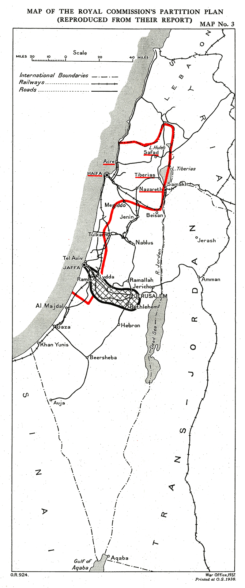
Following the events of 1936, the British established the Peel Commission seeking to understand the causes of the Revolt and the conflict between Jewish and Palestinian and Arab communities. The Commission found that the tenets of the Mandate laid out in the Balfour Declaration (1917) and reiterated in the MacDonald Black letter (1931)—to serve Zionist colonization while ensuring that “nothing shall be done which may prejudice the civil and religious rights of existing non-Jewish communities”—were unworkable. They concluded that the country should be partitioned, cutting it in two: a Palestinian state and Jewish state. They published this recommendation on July 7, 1937. The map drawn by the commission would have placed the Jewish settlement into an area of “international jurisdiction” that stretched from al-Quds to Yafa. Zionist political elites like David Ben-Gurion and Chaim Weizmann hesitantly agreed to the partition plan, seeing it, as historian Benny Morris writes, as a “stepping stone to some further expansion … and eventual takeover of Palestine.”
To my mind, the house in the middle of the road looks like an act of defiance by Jewish settlers angered by the Commission’s plan and Weizmann and Ben-Gurion’s acquiescence to it. Building a house in the middle of the road was a way to both mock the proposed plan and to secure an obstinate claim on the land at a frontier of colonization: a grand political settlement potentially undone by a small colony of mortar.
As I scratched at the provenance and context of the photograph, it became clear that roads and homes in Palestine were not only typical sites of domination—colonizer upon colonized—they were also zones of contestation between colonizer (British) and colonizer (Zionist).
Not yet satisfied with my conclusions, I continued searching the Matson collection to find out if there were other house roadblocks. I found none, but discovered something else.
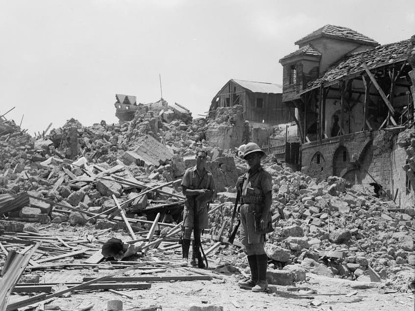
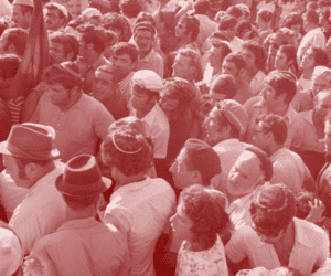
The above picture was taken in the summer of 1936, in what remained of the old city of Yafa. In response to a strike organized by Yafawi workers—as part of the countrywide general strike, which Palestinian elites swiftly co-opted and instrumentalized to demand a (nonviolent) end to Jewish immigration, a ban on land sales to Jews, and independence for Palestine—the British army ripped the city open, forming an anchor shaped path of destruction. Hundreds of homes in the old city were dynamited to make way for three new highways that enabled British forces to traverse, and thus control, the city more easily, displacing an estimated 6,000 Palestinians and Arabs in the process. Posing in front of the administration’s devastating handiwork, the two British soldiers in the photograph appear as hypostatized totems of colonial rule.
The destruction the British inflicted on Yafawi homes reflected the calculus, or lack thereof, of colonization. The British determined that the dislocation of thousands of inhabitants—and eradication of hundreds of years of history—was not even a minor price to pay for order; it bore no weight. We know this because they had not even fully fleshed out a plan to rehouse those made refugees through the demolition.
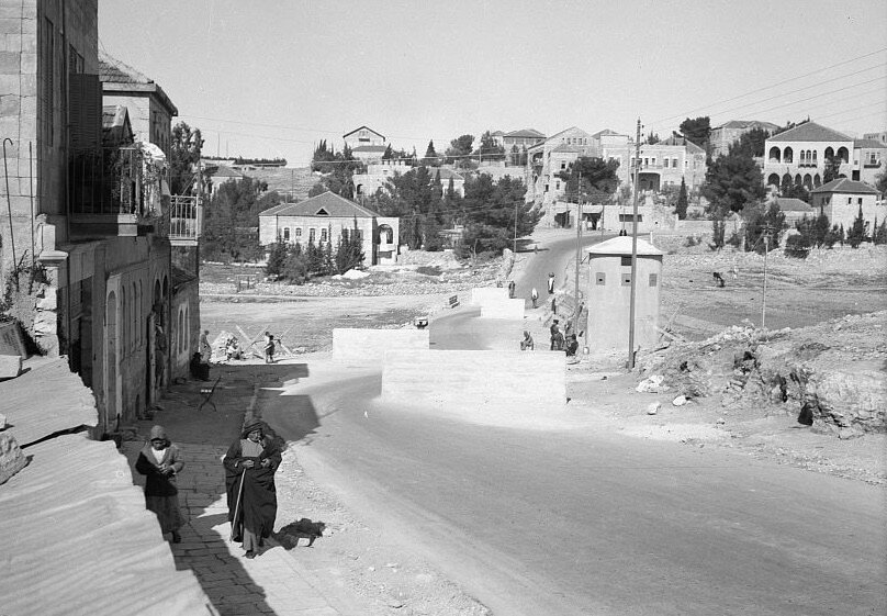
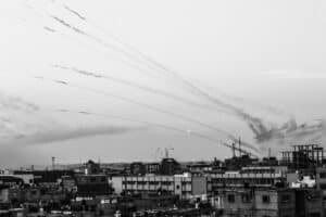
To make further sense of the two photos, I had to return to the issue of the roadblock. I wanted to see if the Jewish house-cum-barrier had a British equivalent. Eventually, I found a photograph of a British “highway” “defense measure” in the Matson collection.
The photograph from 1938 showed a checkpoint on the Nablus Road to the north of al-Quds. In it, a series of concrete blocks burn in the midday sun and choke movement along the road. The roadblocks look new next to the existing structures—shiningly pristine. The British erected checkpoints and other structures like this one in response to the revolutionary gains in the foothills during the second phase of the Revolt (1937–39), aiming to curb thuwwar gains. The image reads like the intersection on a Venn diagram, between the two previous photographs. From settler architecture to state-sanctioned violence, the British checkpoint concretizes the abstract essence underpinning both: the desire to control and order (or disorder) the lives of colonized Palestinian and Arab subjects.
The British took other draconian disciplinary measures to quell the rebellion, including crippling collective fines and mass corporal punishment. Following the city’s significant involvement in the general strike, Nablus was handed a fine of £5,000 Palestinian pounds (approximately £500,000 in 2026), which was claimed in goods like olive oil and soap, hurting local producers and traders. In August 1938, 5,000 Nabulsi men were held in cages for two days and interrogated one after another. Elsewhere, the British tied Palestinians to the front of trains, using them as human shields to ensure the safe movement of their cargo and troops.
It was not until 1939, when the British had effectively rewritten the legal code, undertaken region-wide espionage, set local villages upon one another, tortured and terrorized the population, and deployed 50,000 soldiers and police and 15,000 recruits from the Haganah (a Zionist militia group), that the Revolt was finally defeated.
Considering these images within the context of the Revolt offered me new insights into the importance of homes and roads in the colonization of Palestine. The cataclysm inflicted upon Yafa showed that the right to shelter was never sacrosanct under colonial rule. The al-Quds checkpoint, which acted like a valve, opening and closing at the whims of the British masters, revealed how roads became a tool of pacification. And the house on the road to al-Yehudieh demonstrated that Jewish settlers could simultaneously reproduce the same methods of violence inflicted upon the Palestinian and Arab population by the British, while challenging their rule and cementing their own colonial project upon the landscape.
As I sat in the dar in the late afternoon, covered by the shadow projected by the apartheid wall, it became clear to me that the trio of photographs suggested more than the self-contradiction of the British Authority. They seemed to offer a portent of the cannibal colonialism that would come to fruition during al-Nakba, the ethnic cleansing of Palestine in 1948, when Zionist forces realized their ambition of becoming the colonial hegemon. They did so by repurposing the architecture of British rule which had materialized the essence of colonial power: the domination of the Palestinians. Despite this, however, I found some solace in that grim fact that those tools of oppression used to build the state of Israel, those of the British, are clearly fallible. If the dar could outlive that occupation, why not this one too?