Photo Credit: Wikimedia Commons
_____
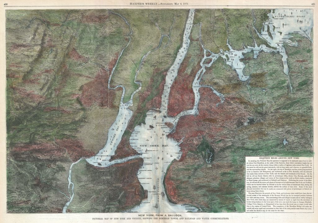
In its May 6, 1871 issue—150 years ago next week—Harper’s Weekly published an extraordinary bird’s-eye view of New York, which was quickly becoming one of the world’s greatest cities. “Eighteen Miles Around New York” is a snapshot of a city still under construction, one that had been transformed well within the lifetime of its average resident. It was continuing to grow and change even as Harper’s readers located themselves on the multi-colored map the magazine had provided.
In 1844, less than a third of Manhattan was urban. As Margaret Fuller wrote to a friend, describing the farmhouse of her boss, Horace Greeley; “The place is, to me, entirely charming,” she wrote. “It is so completely in the country.” The location of the farmhouse? East 49th Street, near what is now the FDR drive. An hourly stagecoach near Third Avenue could bring Fuller and the Greeleys to and from “the city.”
By 1871, however, that city was gobbling up land: the Greeleys had already moved farther north, to Chappaqua, to escape the city. Other New Yorkers in search of peace and quiet frequented Central Park: in 1871, the number of visitors grew to more than 30,000 a day (about 10 million a year.)
But much of what was depicted in the Harper’s map was still farmland or wild in 1871, including parts of Harlem, Washington Heights, and Brooklyn south and east of the Green-Wood Cemetery. Most of Weehawken, the wild New Jersey area where Hamilton fell to Burr in 1804, was still undeveloped in 1871.
Even though the city was not fully developed, it was expanding rapidly, spreading not only out but up. The city depicted on the map was dominated by church spires for much of the 19th century. For most of this period, Trinity Church was the tallest building in New York. But in 1890, it was supplanted by the building erected for Joseph Pulitzer’s New York World, one of the new skyscrapers, pioneered in Chicago a few years earlier, that would reflect the city’s move to a more secular and business orientation. With its splashy headlines, pictures, and comics, the Sunday New York World gave city residents an alternative to church attendance too.
Although the map shows four tiny bridges crossing the Harlem River, linking the city to its new northern suburbs, New York was still a city of ferries. The Brooklyn Bridge project was approved in 1867 but was still in the planning stages in 1871, allowing Brooklyn to remain its own city a few years longer. Washington Roebling began construction of the bridge after his father, bridge designer John Augustus Roebling, was injured in a ferry accident and died of tetanus. The bridge was completed in 1883: two great cities (or as poet Emma Lazarus called them that year, the “twin cities”) would become one, by popular referendum, in 1898.
More changes were in the offing in 1871. One month after Harper’s printed the map, Frédéric Auguste Bartholdi set sail for the United States with a plan to create the Statue of Liberty. On the map, Bedloe’s Island, the statue’s future home, sits southwest of the Battery.
The city depicted on the map was also still dominated by the ships that brought visitors like Bartholdi, immigrants, and European goods to Manhattan’s rail stations. In 1855, Walt Whitman noted in “Crossing Brooklyn Ferry” how the geography and beauty of the waters of the city bound its people together with motion, as it still does now:
Others will enter the gates of the ferry and cross from shore to shore,
Others will watch the run of the flood-tide,
Others will see the shipping of Manhattan north and west, and the heights of Brooklyn to the south and east,
Others will see the islands large and small;
Fifty years hence, others will see them as they cross, the sun half an hour high,
A hundred years hence, or ever so many hundred years hence, others will see them,
Will enjoy the sunset, the pouring-in of the flood-tide, the falling-back to the sea of the ebb-tide.
Harper’s map was drawn in the aftermath of the Civil War, a conflict that had reshaped the city economically and socially. The Draft Riots of 1863, driven by Irish working men’s refusal to serve in the army when wealthy men could refuse, produced a level of mayhem unmatched in the city since the American Revolution. The New York Times was targeted because of its support of Lincoln, and founder Henry Raymond personally manned a Gatling gun to protect his newspaper. The Times building was successfully defended; Greeley’s New York Tribune, a more forceful proponent of abolition, was sacked.
But no group suffered more than the city’s Black residents, many descended from enslaved Africans brought to Manhattan in the 17th century. Mobs attacked, tortured, and killed as many as 1000 African Americans, including orphaned children, and forced others to flee in small boats. “Black people were driven from their homes and all of their property destroyed,” wrote Elizabeth Mitchell. “In the aftermath, some 5,000 Black New Yorkers were discovered hiding on Blackwell’s Island, in police stations, in the swamps of New Jersey and in barns on Long Island, desperately seeking safety from the murderous white crowds.”
In a city that had never been hospitable to people of color, the decade leading up to the drawing of the Harper’s map was surely one of the worst ever. In 1870, the city reported fewer Black residents than in 1860. And the hostility outlasted the war: a move to expand voting rights for Blacks in New York failed in 1869.
We tend to think of New York’s expansion in positive terms, but building a modern city meant displacement for many, so that the land could be speculated on, resold, and developed for more genteel or ambitious purposes. The creation of Central Park in 1859 had involved the clearing out of a number of poor and working communities of Irish, German, and Black residents. After the Civil War, this kind of redevelopment was taken for granted by business and politicians alike. The city was dominated by corporate interests in 1871, and the mayor, Tammany politician A. Oakey Hall, headed a racket that had its mind on its money and its money on its mind as businessmen expanded their hold on New York.
But if the physical map suggested a city getting richer and bigger, some of its neighborhoods were becoming denser and more crowded. Downtown, New York’s streets teemed with new immigrants and communities were starting to form around ethnic identity groups. The Central Synagogue, one of New York’s grandest houses of worship, was completed in 1872 on 55th street and Lexington Avenue, reflecting a rising Jewish presence. To the west, an even more majestic structure, St. Patrick’s Cathedral, had resumed construction halted during the Civil War, reflecting the growing power of Irish Catholics among the city’s business and political elites.
Harper’s map, like the earthrise-over-the-moon photo a century later, astounded its audience. But of the many things depicted in it, one element is missing: people. New York was, as it is today, far less interesting from a balloon than it was on the streets, where the most momentous transitions could be felt: noise, smells, commerce, strikes, and the sights and sounds of a city on the make. This is what Frederick Douglass experienced when he tested his newly free legs on the streets of New York City after escaping slavery in 1838. Or what a young Teddy Roosevelt saw when he peered out his grandparents’ New York City window in 1865 at Abraham Lincoln’s funeral entourage. It was what the Greeley family fled when they moved to Chappaqua, and how Auguste Bartholdi first experienced America when he stepped off the gangplank of his trans-Atlantic steamer.
“Eighteen Miles Around New York” depicted the city few of these visionaries would ever see. By the time flight made widespread aerial views possible, skeptics wondered if it was worth it. Writing in 1920, Walter Lippmann saw ballooning as a metaphor for a lack of specificity, a blurring that obscured what might otherwise be seen. “As you go up in the balloon…you see far and wide, but you see very little,” he wrote.
Many would agree today. Historian John Kasson finds “bird’s-eye views” less interesting than “mole’s-eye views.” As he and other urban historians have argued, the most interesting aspects of 19th century cities were the crowds and the individual people moving through the city landscape. The throng of humanity is what binds New York together, across years, across centuries. But those people moved through space—on bridges, roads, and waterfront transportation, that could only truly be seen from above.
For the earthbound, New York could only be experienced from the “mole’s eye view,” and the panorama could only be imagined. As Walt Whitman writes in “Crossing Brooklyn Ferry:”
I too lived, Brooklyn of ample hills was mine,
I too walk’d the streets of Manhattan island, and bathed in the waters around it,
I too felt the curious abrupt questionings stir within me,
In the day among crowds of people sometimes they came upon me,
In my walks home late at night or as I lay in my bed they came upon me.
New York City in 1871 was striving, forceful, and fascinating in ways that the map in Harper’s Weekly could, and could not, capture. But it was an act of imagination that pointed New Yorkers toward their collective future.
_____
David T. Z. Mindich is the chair of the journalism department at the Klein College of Media and Communication at Temple University.